|
|
Post by Dave on Nov 16, 2013 7:00:50 GMT -9
Starting a new battle map: a grassy field with a river running through it. Need your opinions about which of these river courses is best. 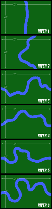 |
|
|
|
Post by WackyAnne on Nov 16, 2013 7:04:00 GMT -9
My vote is for number 3, then number 5, although 5 would require more an explanation for the dibit in the loop. A rock or something.
|
|
|
|
Post by Vermin King on Nov 16, 2013 12:20:39 GMT -9
It really all depends on a person's scenario. For me number 4 would work best, as I would just be using it for a diorama, with a medieval village on the larger land mass.
|
|
|
|
Post by wyvern on Nov 17, 2013 2:47:35 GMT -9
For land-based wargaming, central tabletop rivers only really work if there's one or more crossing points, so that element's probably of greater significance than the actual line of the river. I'd suggest keeping the watercourse line fairly simple though, given that any very meandering course in real-world terms would mean small lakes and marshes alongside, where no commander with good sense would choose to fight.
|
|
|
|
Post by afet on Nov 23, 2013 15:44:26 GMT -9
I like 3 and 4.
|
|
|
|
Post by hackbarth on Nov 24, 2013 13:05:36 GMT -9
The 1, although very uninteresting artistically is an obligatory piece, you couldn't release a set that didn't had a simple straight course.
I also like 2 and 3.
|
|
|
|
Post by Dave on Jan 18, 2014 12:36:07 GMT -9
Well, I'm shelving this idea for now, and will let it swim around in my head some more.
|
|
|
|
Post by WackyAnne on Jan 18, 2014 13:28:57 GMT -9
Ah, I was looking forward to what you came up with. But if you've not got a clear vision, from us or yourself, then it is best to let it marinate until you do.
|
|
|
|
Post by stevelortz on Jan 18, 2014 17:40:41 GMT -9
If I were setting up a miniatures battle, with the set on areas being about a foot or so from each of the long edges, I would definitely use map #3. I would have at least two fords or bridges. If it were eight feet wide, I would use a bridge and two fords.
What if you did a map with enough sections to cover an area twelve feet long? The course of the river could vary over the twelve feet. A customer could vary the number of 6 foot fields she/he could use, and the course of the river, by selecting which section of the 12 foot map to print out.
If you made the two ends of the twelve foot map geomorphic, you could make the possibilities almost infinite!
And if you put a half twist in it, you could make it a moebius map!
Have fun!
Steve
|
|
|
|
Post by Dave on Jan 19, 2014 9:33:47 GMT -9
Yeah, I'm thinking about ways to do this so it's infinitely tile-able, but now I'm dealing with technical issues that might make it impossible for me to create large maps at all until I get a new PC.
|
|


